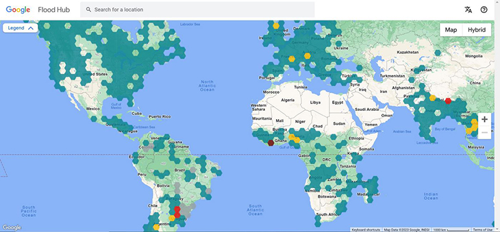
In its quest to extend beyond conventional search engine functions, Google has emerged as an unexpected hero in disaster prevention, particularly in protecting developing countries from the ravages of flooding.
The tech giant’s Flood Hub, a modeling tool launched in 2018, has proven instrumental in issuing timely warning and enabling proactive evacuations, exemplified in the recent floods that struck the Chilean areas of Constitucion and Maule.
Riverine floods, characterized by rivers overflowing their banks due to heavy rains, are often underestimated as natural disasters. The intricate nature of predicting these floods had long posed a challenge, considering factors beyond conventional weather reports, including soil composition, topography, and potential infrastructure vulnerabilities.
Google’s Flood Hub disrupts this notion by harnessing the power of satellite data and machine learning. The tool’s foundation lies in analyzing thousands of detailed satellite images of waterways, providing a comprehensive topographical understanding of a river’s course.
This information is augmented with scientific data on flooding rates, soil composition, erosion history, and more. The amalgamation of these elements is then processed through a deep-learning program, culminating in flooding models enriched by real-time weather forecasts and rainfall data.
Yossi Matias, vice president of engineering and research at Google, said, “This was really kind of a moonshot, in a way. Can we use machine learning and other technologies in order to try to predict floods at some level of accuracy that would be valuable?”
The outcome of this innovative approach is the global hydrologic model, a sophisticated tool that has been deployed across numerous countries over the past five years. Recently introduced in the United States and Canada, Flood Hub has proven its efficacy during this monsoon season in India and Bangladesh, issuing a staggering 45 million alerts to potentially affected communities.
When Flood Hub detects an impending flood, it employs various communication channels to disseminate alerts. In some countries, citizens receive alerts directly on their phones akin to the Amber Alert system in the United States. Alternatively, alerts are forwarded to relevant government departments, which then utilize their communication networks. In extreme cases, outreach efforts extend to physical visits, with authorities knocking on doors on leveraging platforms like WhatsApp to ensure widespread dissemination of critical information.
Matias told Adele Peters of Fast Company Magazine while reporting on the tool, “It allowed us to provide flood forecasting information even in places where the historical data is quite scarce.”
“For example, [we’re in] 23 countries in Africa, many of which actually don’t have enough data, but because we can learn the patterns of floods and then map them to places that have certain similarities, it allows them to get to the right level of quality that we needed,” he added.
Google has taken its commitment to disaster relief a step further by collaborating with Give Directly, a disaster recovery non-governmental organization (NGO). This partnership introduces a groundbreaking platform that enables direct financial assistance to individuals who receive Flood Hub evacuation alerts. By providing funds for relocation, this initiative empowers vulnerable communities to undertake necessary measures for their safety and well-being.
In retrospect, Google’s Flood Hub not only transcends its traditional role as a search engine but also stands as a testament to the positive impact technology can have on disaster preparedness and response. As the tool continues to evolve and expand its reach, it holds the promise of becoming a global standard in safeguarding communities against the often underestimated threat of riverine floods.
What are your thoughts? Please comment below and share this news!
True Activist / Report a typo


